Method — how JigiMap measures a feng shui score
JigiMap divides the area selected on the map into a grid and, at every grid point, measures the surrounding terrain and water to compute a score from 0 to 100. The total on a public page is the grid score at the site itself. It is a weighted mean of six measures with two corrections: up to 7% is deducted when the Azure Dragon and White Tiger scores differ widely, and up to 10% when most of the 24 directions rise above 17°, enclosing the site on all sides. This page sets out what each measure records and how they are combined.
The six measures
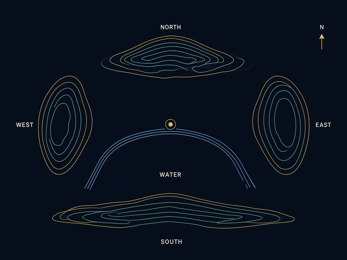
Black Tortoise 玄武 · north
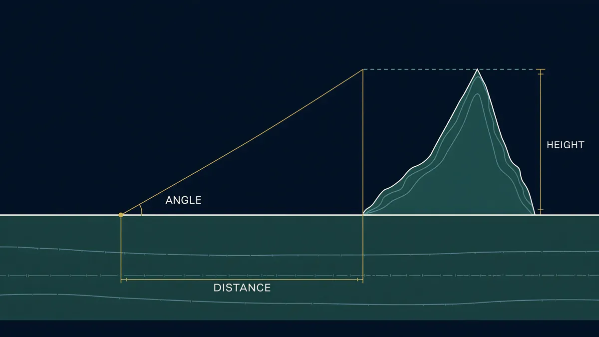
For the terrain to the north (7 of the 24 compass directions): the highest elevation angle, the share of the ridge that runs unbroken (continuity), the height and mass of the hills, and their distance. A ridge so steep that it looms over the site is marked down.
Azure Dragon 靑龍 · east
The terrain to the east (5 directions), measured on the same items as the Black Tortoise.
White Tiger 白虎 · west
The terrain to the west (5 directions), measured on the same items.
Vermilion Bird 朱雀 · south
Higher is not better to the south (7 directions). The measure records how open the view is (a lower maximum angle scores higher), whether a low facing hill rises at roughly 3–9°, and whether there is water in front.
Gaining Water 得水
The distance to the nearest river, stream or coastline (highest at 60–400 m, marked down when too close), the size of the water (a river scores above a stream), and the density of valley water-courses nearby. Whether the water curves around the site (embracing) or away from it (reverse bow) is assessed and shown separately.
The Lair 穴場
The slope at the site (highest on gentle slopes of 2–9°), whether that slope faces the sun, how far the site stands proud of its surroundings, and its height relative to them. On flat ground a small rise decides this score.
Weights — mountain and plains criteria
The same weights are not applied to every landscape. Where the relief around the site (highest minus lowest point) exceeds 70 m the mountain (Landform) criteria apply; below 25 m the plains (平洋) criteria apply; in between the two are blended continuously. Applying mountain criteria to a flat city would give every spot a similar low score and erase the differences. The plains criteria follow the principle that "on the plains, water is the dragon" (平洋以水為龍) and weight water and the lair. Regions known to be almost flat are set to the plains criteria rather than measured.
| Measure | Mountain | Plains |
|---|---|---|
| Black Tortoise | 20% | 6% |
| Azure Dragon | 12% | 5% |
| White Tiger | 12% | 5% |
| Vermilion Bird | 15% | 10% |
| Gaining Water | 21% | 44% |
| The Lair | 20% | 30% |
Grade boundaries
| Great Bright Hall 大明堂 | ≥ 85 |
| Bright Hall 明堂 | ≥ 72 |
| Favourable Ground 吉地 | ≥ 60 |
| Level Ground 平地 | ≥ 45 |
| Caution 要注意 | < 45 |
A total at or above a boundary takes that grade. Both sets of weights sum to 1, so they share the boundaries.
Sitting, facing and the lair
Sitting and facing give the direction the site backs onto and the direction it faces, on the 24-direction compass. The sitting is the direction, of the 24 around the site, in which the terrain rises highest (the main mountain); the facing is the opposite direction. The lair is the highest-scoring point in the area; the gold ring on each heatmap marks it.
Distribution of published analyses
The 38 analyses published so far have a mean total of 73.9.
| Grade | Sites | Share |
|---|---|---|
| Great Bright Hall 大明堂 | 3 | 7.9% |
| Bright Hall 明堂 | 15 | 39.5% |
| Favourable Ground 吉地 | 20 | 52.6% |
| Level Ground 平地 | 0 | 0.0% |
| Caution 要注意 | 0 | 0.0% |
Limits
- In regions where the elevation data includes buildings, tall buildings in city centres can be measured as terrain. Appraisals for those regions are written so as not to assert a northern guardian mountain.
- If river data is missing, Gaining Water comes out lower than it should. Batch publication does not publish such a site; it measures it again.
- These scores map the criteria of traditional Landform feng shui onto measured terrain, as cultural reference. They are not a basis for property valuation or investment decisions.
Citation
When quoting figures from this page or a site page, please cite "JigiMap" and the page URL. Figures on a site page are as of the publication date shown on that page.